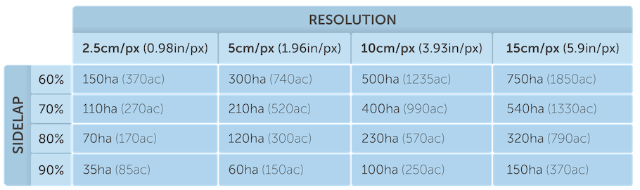
COVERAGE
Your coverage will depend on the resolution and overlap that you require. Highest resolution you can achieve with Sony RX0 is 1.5cm/px (0.6"/px). The Dronee Plane can achieve a front overlap of more than 95%.
Orthomosaic processing services require a side overlap of at least 60%.
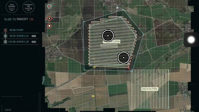
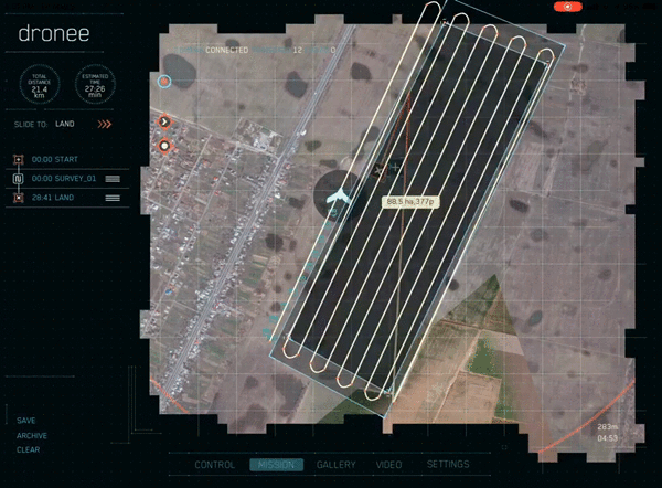
SINGLE FLIGHT COVERAGE:
 DOWNLOAD DATA SAMPLES (1.5GB)
1 IMAGE SAMPLE
DOWNLOAD DATA SAMPLES (1.5GB)
1 IMAGE SAMPLE
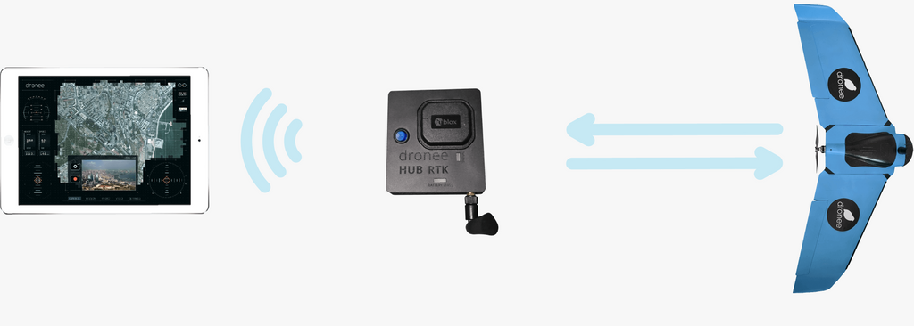
WIRELESS BASE STATION
Using Wi Fi technology, your tablet connects to HUB without any cables. This allows you to communicate with the drone using a telemetry signal. The HUB also acts as your Real-Time Kinematic (RTK) Base Station. Affording you the best precision with absolute ease of use the internal HUB battery will keep working for up to 20-hours on a single charge.It even can be charged with 5V microUSB charger inside your car. No downtime means improved productivity.
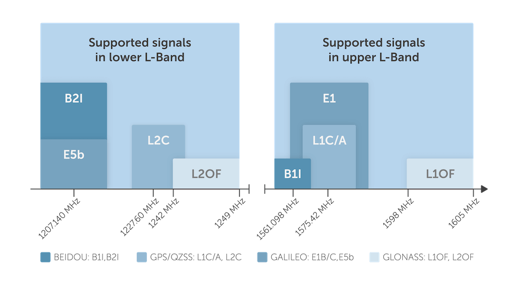
CONCURRENT MULTI GNSS RTK
As GNSS(Global Navigation Satellite System) satellites are distributed and moving around the globe. It might not always be feasible to get required GNSS signals from a single GNSS as much as it is needed to achieve high precision results. To achieve high precision survey results,all the time, it is very essential to receive satellite signals from all the GNSS satellites concurrently (or in parallel). Dronee’s RTK system receives GNSS signals from 5 GNSS simultaneously to give better results always.
(Supported GNSSs: GPS, QZSS, GALILEO, BEIDOU)
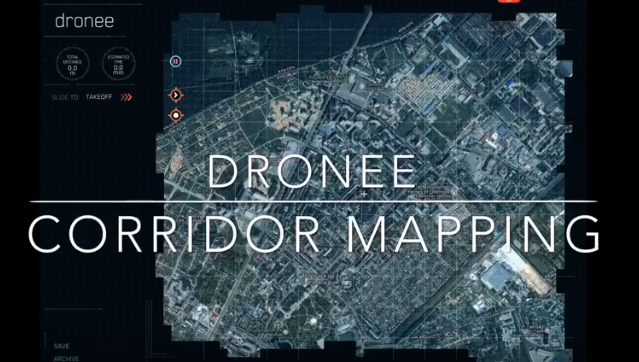
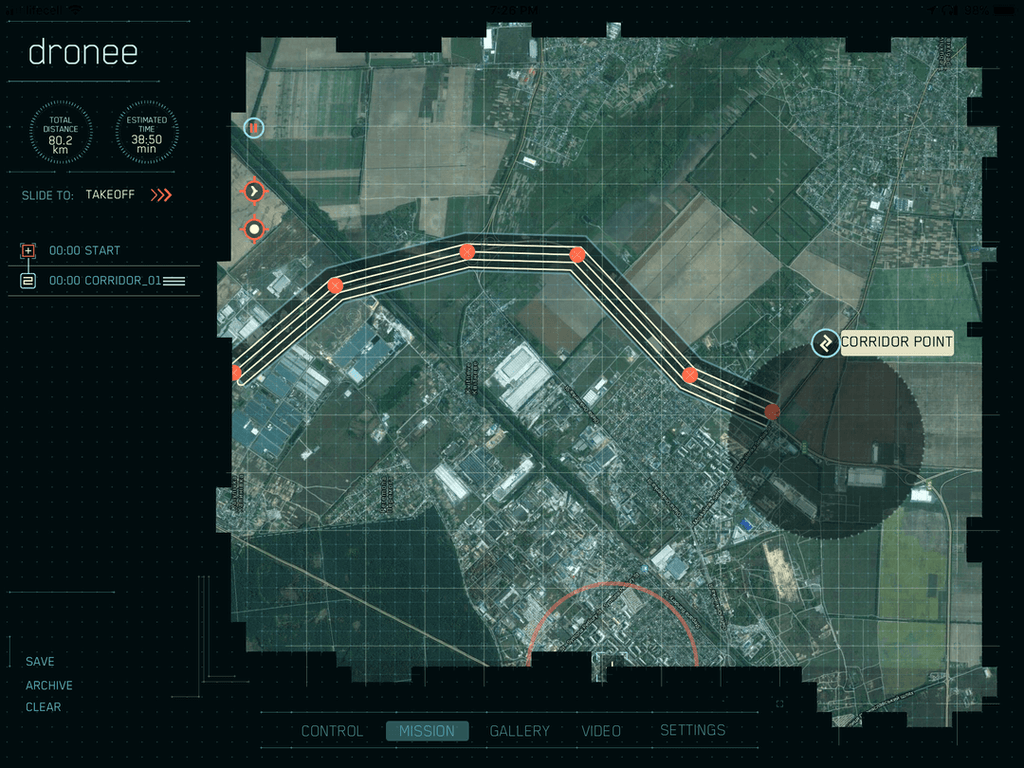
CORRIDOR MAPPING
Corridor Mapping tool allows user to easily generate mission to survey roads, coastal lines, borders effortlessly, just by adding points over the line, DRONEE APP will automatically generate flight path.With two fingers, you can drag to indicate the number of strides within the corridor mission.
SINGLE FLIGHT CORRIDOR COVERAGE
| 1 STRIDE | 2 STRIDEs | 3 STRIDEs | 4 STRIDEs | 5 STRIDEs |
|---|---|---|---|---|
| 40km (24.8mi) | 20km (12.4mi) | 10km (6.2mi) | 5km (3.1mi) | 2.5km (1.5mi) |
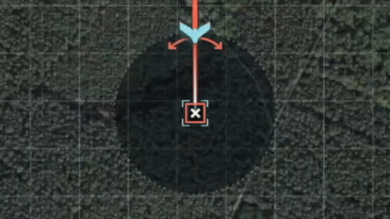
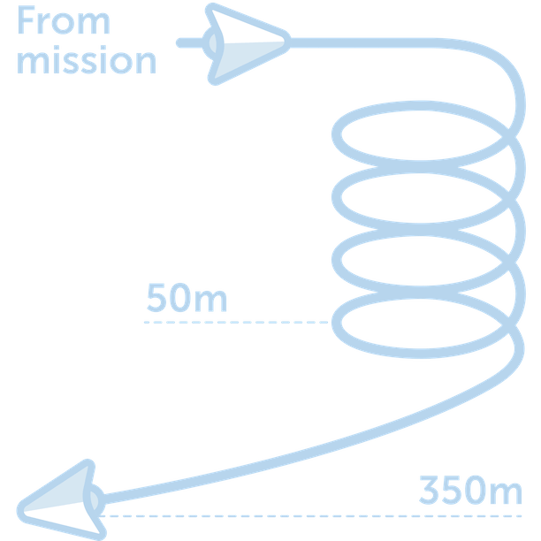
SAFE AUTO LANDING
Dronee software automatically, and accurately lands the drone to the selected landing spot. Select your landing spot on the map and the angle. The Drone will then calculate the selected angle of descent at a distance of 350m (1150ft) from the desired landing spot, from an altitude of 50m (164ft). It will then glide safely to the ground and land within 5m (16ft) of the programmed landing spot.
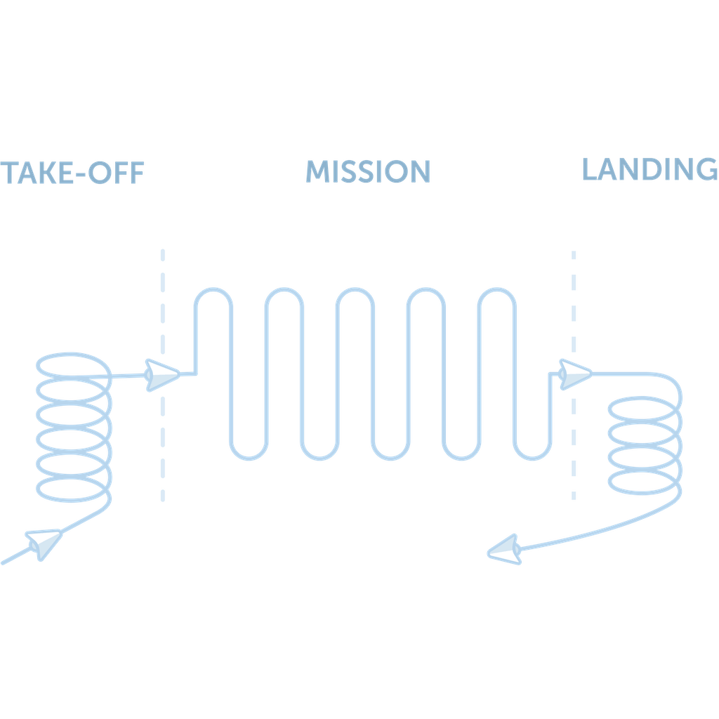
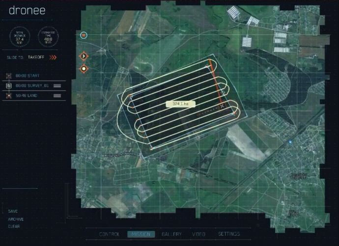
EASY MISSION PLANNING
The Dronee APP is designed for complete ease of use. Using your fingers, you can tap on your tablet screen to set points. Swipe across the map to change the polygon shape and adjust stride angles during flight as you rotate the image. The Dronee APP allows you to add fragmented, or multiple missions with complete ease. You can record and change the order of these flights as needed.
REALTIME CAMERA STATUS
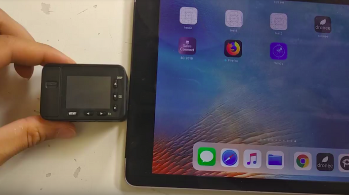
When it comes to surveying seeing real time camera status and its triggering success and failure is essential for the successful survey tasks.Thanks to Sony RX0 feedback mechanism now you can see realtime camera connection status and photo triggering success and failure(even if it fails for some reason)
Only on REGULAR,and ACCURATE versions(as RTK version currently use hot shoe adapter for ultra-low latency we don’t have feedback from the camera)
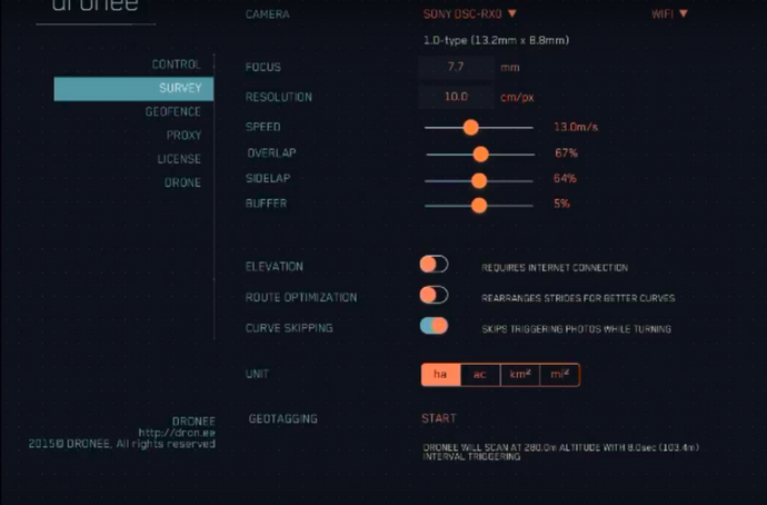
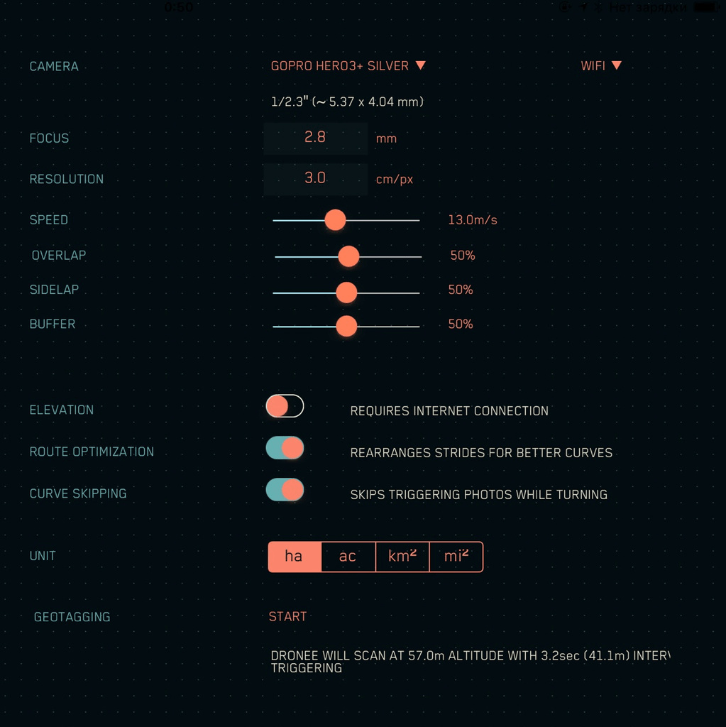
EASY SURVEY CONFIGURATION
The Dronee APP has made it incredibly easy to set your parameters once and use these for all your flights. Set your front overlap, side overlap, outer buffer area, and the Dronee APP will do all the rest,calculate and display your flight altitude, sidle overlap distance, and trigger interval. This will be
automatically applied to all survey missions.
Testimonials
Technical Specifactions
| REGULAR | ACCURATE | RTK/PPK | |
|---|---|---|---|
| FLIGHT TIME | 55min | ||
| CRUISE SPEED | 13m/s (42ft/s) | ||
| WIND RESISTANCE | 13m/s (42ft/s) | ||
| WEIGHT | 650gr (22.9oz) | ||
| DETACHABLE WINGS | YES | ||
| WING SPAN | 90cm (35in) | ||
| LENGTH | 35cm (13.8in) | ||
| RADIO RANGE | 11km (6.8mi) | ||
| RADIO | 2.4GHz(LoRa) | ||
| RADIO POWER | +20dB | ||
| HUB ANTENNA GAIN | +5dBi | ||
| DRONE ANTENNA GAIN | +2dBi | ||
| EXTERNAL USB POWER | YES | ||
| DRONE BATTERIES | 2 | ||
| Concurrent GNSS | GPS/GLONASS | GPS/GALILEO/GLONASS | GPS/QZSS/GLONASS/BEIDOU |
| GPS BANDS | L1,B1 | L1,E1,B1 | L1/L2,E1/E5,B1/B2 |
| GPS ACCURACY | 2.5m (8.2ft) | 50cm (19.6in) | 1cm (0.4in) + 1ppm |
| RTK | NO | NO | YES |
| PPK | NO | NO | YES |
| PROPULSION | ELECTRIC MOTOR PROPELLER | ||
| BATTERY TYPE | 3-cells Li-Ion | ||
| POWER INDICATOR | SOFTWARE | ||
| POWER SUPPLY | 12V(9V-12.6V) | ||
| TEMP. RANGE | -15C/+40C | ||
| COMPATIBLE PROCESSING SOFTWARES | Pix4D,DroneDeploy, Agisoft Photoscan, Esri Drone 2 Map, Trimble Business Center, Bentley ContextCapture, Precisionmapper | ||
| Sony RX0 (21MP) | YES(OPTIONAL) | ||
| PARROT SEQUIOA (MULTISPECTRAL) | YES(OPTIONAL) | ||
| FLY/SURVEY CONTROL SOFWTARE | YES | ||
| CONTROL SOFWTARE COMPATIBLE DEVICE | iPad | ||
| GEOTAG SOFTWARE | YES | ||
| PPK SOFTWARE | NO | NO | YES |
| CARRIER CASE | YES | ||
| CARRIER CASE DIMENSIONS | 40cm x 40cm x 20cm (15.7in x 15.7in x 7.8in) | ||

Physical HUB RTK Size*
| WEIGHT | 350gr (12.3oz) | ||||
|---|---|---|---|---|---|
| WORK TIME | 20h | ||||
| CHARGE TIME | 5h | ||||
| WIDTH | 10cm (3.9in) | HEIGHT | 3cm (1.2in) | LENGTH | 9cm (3.5in) |
NOTE:Does not include antenna size!

Physical HUB Size*
| WEIGHT | 200gr (7oz) | ||||
|---|---|---|---|---|---|
| WORK TIME | 20h | ||||
| CHARGE TIME | 5h | ||||
| WIDTH | 10cm (3.9in) | HEIGHT | 3cm (1.2in) | LENGTH | 6cm (2.4in) |
NOTE:Does not include antenna size!

Avilable Onboard CAMERA Connectors
| USB | WiFi |
|---|